
Kettle Moraines Most Scenic Lakes and Trails
Sightseeing
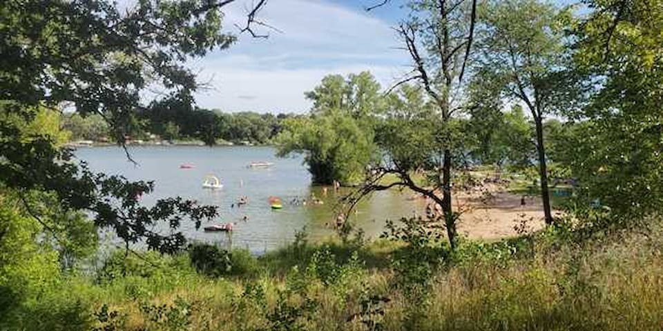
812 Wrigley Drive, Lake Geneva, WI (18 miles) A fantastic swimming beach. In my opinion Lake Geneva and its beaches (always crowded) are a MUST SEE when visiting the area.
10 personas locales recomiendan
Riviera Beach
812 Wrigley Dr812 Wrigley Drive, Lake Geneva, WI (18 miles) A fantastic swimming beach. In my opinion Lake Geneva and its beaches (always crowded) are a MUST SEE when visiting the area.
N7698 State Park Road, Whitewater, WI (10 miles)
Swimming beach on Whitewater Lake in the Kettle Moraine State Forest. There is a COMPLIMENTARY Wisconsin State Park Pass available to our guests.* You will need a pass for state park access and parking. Picnic coolers and beach chairs are also available for our guests use. At the lake front there are tables, grills and toilet facilities The park also has hiking trails, and fishing. Grab a picnic basket, some beach towels , and prepare for a fun-filled day.
Whitewater Lake Beach
N 7698N7698 State Park Road, Whitewater, WI (10 miles)
Swimming beach on Whitewater Lake in the Kettle Moraine State Forest. There is a COMPLIMENTARY Wisconsin State Park Pass available to our guests.* You will need a pass for state park access and parking. Picnic coolers and beach chairs are also available for our guests use. At the lake front there are tables, grills and toilet facilities The park also has hiking trails, and fishing. Grab a picnic basket, some beach towels , and prepare for a fun-filled day.
348-352 Lakeshore Drive, Fontana, WI (17 miles)
On the western shore of Geneva Lake is the Village of Fontana Beach, a large sandy beach with wide grassy area and changing rooms. Lifeguards are on duty from Memorial Day weekend until Labor Day, seven days a week, from 9:30 am to 6 pm.
17 personas locales recomiendan
Fontana Beach
South Lake Shore Drive348-352 Lakeshore Drive, Fontana, WI (17 miles)
On the western shore of Geneva Lake is the Village of Fontana Beach, a large sandy beach with wide grassy area and changing rooms. Lifeguards are on duty from Memorial Day weekend until Labor Day, seven days a week, from 9:30 am to 6 pm.
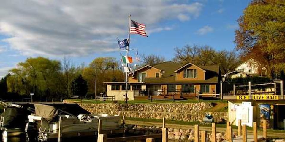
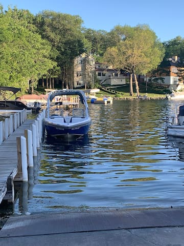
W 5625 Westshore Drive, Elkhorn, WI (5 miles) Lauderdale Lakes PUBLIC boat launch - Bar and Grill. The Landing has fantastic outdoor seating, great pizza and live music on the weekends. Expect a lot of FIBS (friendly Illinois brethren) on the weekends and summer.
7 personas locales recomiendan
Lauderdale Landing
W5625 Westshore DrW 5625 Westshore Drive, Elkhorn, WI (5 miles) Lauderdale Lakes PUBLIC boat launch - Bar and Grill. The Landing has fantastic outdoor seating, great pizza and live music on the weekends. Expect a lot of FIBS (friendly Illinois brethren) on the weekends and summer.
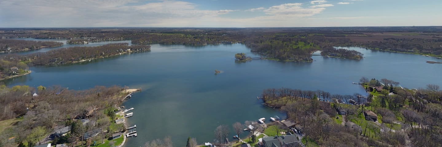
Visitors to Green, Middle and Mill Lake - LAUDERDALE LAKES CHAIN (1.1 mile) have more than 1500 acres of sparkling water to explore, plus several small islands. Because the lakes are connected, boaters and paddlers can make their way around 16 miles of meandering shoreline. Fishing in the lakes is excellent with large populations of northern pike, largemouth bass, smallmouth bass, walleye, crappie and bluegill. A public boat ramp on the southwest shore of Middle Lake grants visitors access to the wide open water. Attempt to visit on a weekday, vs. the weekend.
Lauderdale Lakes
Visitors to Green, Middle and Mill Lake - LAUDERDALE LAKES CHAIN (1.1 mile) have more than 1500 acres of sparkling water to explore, plus several small islands. Because the lakes are connected, boaters and paddlers can make their way around 16 miles of meandering shoreline. Fishing in the lakes is excellent with large populations of northern pike, largemouth bass, smallmouth bass, walleye, crappie and bluegill. A public boat ramp on the southwest shore of Middle Lake grants visitors access to the wide open water. Attempt to visit on a weekday, vs. the weekend.
8180 High Ridge Road, Elkhorn, WI (4 miles) A Peaceful and beautiful lake, many tourists don't know about. Motor boats and jet skis cannot be on this no wake zone lake. It's quiet and clean. Eagles are great to view from your paddle board or kayak.
Pleasant Lake
8180 High Ridge Road, Elkhorn, WI (4 miles) A Peaceful and beautiful lake, many tourists don't know about. Motor boats and jet skis cannot be on this no wake zone lake. It's quiet and clean. Eagles are great to view from your paddle board or kayak.
N7536 Sterlingworth Drive, Elkhorn, WI (3 miles) PRIVATE BOAT LAUNCH and Marina. Boat launch and slip privileges with LONG term rental only. If you do NOT want the hassle and expense of launching your boat check with your host for lake access.
The Boat House of Lauderdale Lakes
N7536 Sterlingworth Drive, Elkhorn, WI (3 miles) PRIVATE BOAT LAUNCH and Marina. Boat launch and slip privileges with LONG term rental only. If you do NOT want the hassle and expense of launching your boat check with your host for lake access.
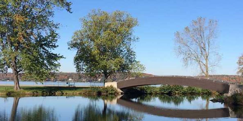
1550 S Lake Shore Drive, Lake Geneva, WI (19 miles) Show off your selfie skills! Find a selfie stand located just off of the paved path about 30 feet from Ceylon Lagoon looking over Geneva Lake and stop for a fun photo. Share yours with us on Instagram using #ScenicWisconsin.
Located on the shores of Lake Geneva, the park offers wooded campsites, a sand beach, and picnic areas. Open year round.
20 personas locales recomiendan
Big Foot Beach State Park
1550 S Lake Shore Dr1550 S Lake Shore Drive, Lake Geneva, WI (19 miles) Show off your selfie skills! Find a selfie stand located just off of the paved path about 30 feet from Ceylon Lagoon looking over Geneva Lake and stop for a fun photo. Share yours with us on Instagram using #ScenicWisconsin.
Located on the shores of Lake Geneva, the park offers wooded campsites, a sand beach, and picnic areas. Open year round.
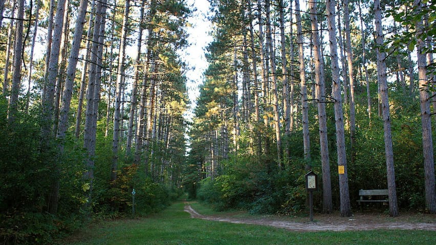
N9097 CTH - H, Whitewater, WI (6 miles) A trail for mountain bikes, hiking or cross country skiing. In the fall or winter the trails are closed to mountain bikes, a fantastic place for a hike. The trails are concentric and you can basically pick your mileage as you go! There is also a nice picnic area here, and beginner mountain bike trails for kids.
14 personas locales recomiendan
John Muir Hiking-Biking Trails
N9097 Co Rd HN9097 CTH - H, Whitewater, WI (6 miles) A trail for mountain bikes, hiking or cross country skiing. In the fall or winter the trails are closed to mountain bikes, a fantastic place for a hike. The trails are concentric and you can basically pick your mileage as you go! There is also a nice picnic area here, and beginner mountain bike trails for kids.
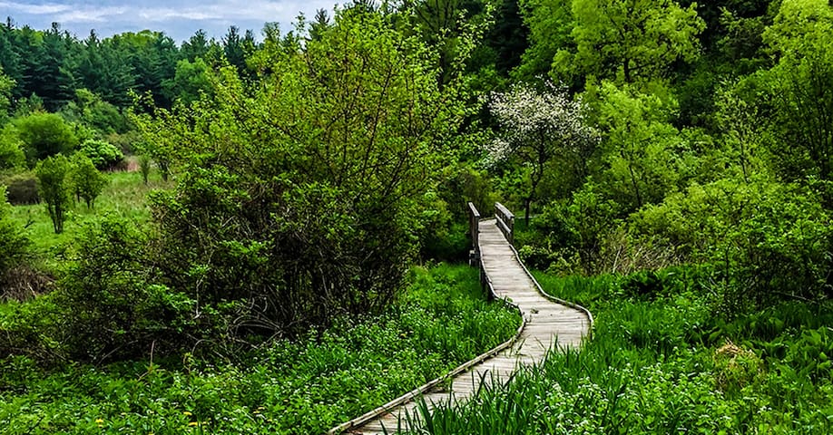
Find the Scuppernong trail system on County ZZ (Kettle Moraine Scenic Drive) east of Highway 67, north of the Village of Eagle. Distance: 5.6 miles.
There are three color-coded loop trails ranging from 2 to 5 miles. The Scuppernong area provides convenient parking, water and a vault toilet. The trails have a nice rolling characteristic through hardwood forest and pine plantations. Bikes are not allowed on this trail system. Scuppernong Trail map [PDF].
Red Loop - intermediate - 2.3 miles: Short and narrow with steep terrain is the only way to describe this loop. You’ll pass through pine plantations and hardwood forest.
Orange Loop - intermediate - 4.1 miles: This loop will take you deeper into the hardwood forest.
Green Loop - advanced - 4.9 miles: About halfway on this loop, you will pass the edge of the Pinewoods Campground. As you continue through the pines, walk quietly down these old fire lands. When making your final descent from the ridge to the parking lot, you will experience a roller coaster of hills that you won’t soon forget. Enjoy a seat on the overlook with views of Ottawa Lake and the surrounding area.
8 personas locales recomiendan
Scuppernong Trail Head
S58 W35820 County Road ZZFind the Scuppernong trail system on County ZZ (Kettle Moraine Scenic Drive) east of Highway 67, north of the Village of Eagle. Distance: 5.6 miles.
There are three color-coded loop trails ranging from 2 to 5 miles. The Scuppernong area provides convenient parking, water and a vault toilet. The trails have a nice rolling characteristic through hardwood forest and pine plantations. Bikes are not allowed on this trail system. Scuppernong Trail map [PDF].
Red Loop - intermediate - 2.3 miles: Short and narrow with steep terrain is the only way to describe this loop. You’ll pass through pine plantations and hardwood forest.
Orange Loop - intermediate - 4.1 miles: This loop will take you deeper into the hardwood forest.
Green Loop - advanced - 4.9 miles: About halfway on this loop, you will pass the edge of the Pinewoods Campground. As you continue through the pines, walk quietly down these old fire lands. When making your final descent from the ridge to the parking lot, you will experience a roller coaster of hills that you won’t soon forget. Enjoy a seat on the overlook with views of Ottawa Lake and the surrounding area.
Co Road H, Palmyra, WI (8 miles) County Highway H south of Palmyra on east side of the road. One of the highest points in Jefferson County, Hike to the top of the bluff, a former Indian signal hill. 0.5 miles. Bald Bluff nature trail [PDF].
9 personas locales recomiendan
Bald Bluff Nature Trail
County Road HCo Road H, Palmyra, WI (8 miles) County Highway H south of Palmyra on east side of the road. One of the highest points in Jefferson County, Hike to the top of the bluff, a former Indian signal hill. 0.5 miles. Bald Bluff nature trail [PDF].
County Road Z, Palmyra, WI (11 miles) This trail system, on County Highway Z just south of State Highway 59, goes through a hardwood forest with mostly hilly terrain. Three color-coded trails ranging from 3.5 to 8 miles. Parking, water and vault toilets are available. The trails in this system are single-track mountain bike trails that are generally more difficult than the John Muir Trails. Trail map [PDF].
Brown Loop, moderate, 3.5 miles: Skirt in and out of pines and hardwoods, pass a kettle lowland, then after joining up with the Orange Loop, proceed uphill along a moraine and back downhill to the trailhead.
Orange Loop, moderate/hard, 6 miles: Traverse the contours of the glacial geography, generally uphill to the scenic overlook where the Connector trail meets the Carlin trails. Then get ready for lots of ups and downs until meeting back with the Brown Loop.
Green Loop, hard, 8 miles: This trail is continuous with the Orange Loop until it splits off on the southern half of the loop. Here you are in for several difficult ups and downs.
14 personas locales recomiendan
Emma Carlin Trail Head
County Road ZCounty Road Z, Palmyra, WI (11 miles) This trail system, on County Highway Z just south of State Highway 59, goes through a hardwood forest with mostly hilly terrain. Three color-coded trails ranging from 3.5 to 8 miles. Parking, water and vault toilets are available. The trails in this system are single-track mountain bike trails that are generally more difficult than the John Muir Trails. Trail map [PDF].
Brown Loop, moderate, 3.5 miles: Skirt in and out of pines and hardwoods, pass a kettle lowland, then after joining up with the Orange Loop, proceed uphill along a moraine and back downhill to the trailhead.
Orange Loop, moderate/hard, 6 miles: Traverse the contours of the glacial geography, generally uphill to the scenic overlook where the Connector trail meets the Carlin trails. Then get ready for lots of ups and downs until meeting back with the Brown Loop.
Green Loop, hard, 8 miles: This trail is continuous with the Orange Loop until it splits off on the southern half of the loop. Here you are in for several difficult ups and downs.
Explore the 30 miles of Ice Age Trail that goes from the southernmost end to the northernmost point of the Kettle Moraine State Forest-Southern Unit. There is a "hard Copy" of the Ice Age Trail Map COMPLIMENTARY and available for our guests use. The Kettle Moraine SOUTH is a part of the Ice Age National Trail network that eventually will go 1,000 miles through some of Wisconsin's most scenic areas.
6 personas locales recomiendan
Ice Age Trail
Explore the 30 miles of Ice Age Trail that goes from the southernmost end to the northernmost point of the Kettle Moraine State Forest-Southern Unit. There is a "hard Copy" of the Ice Age Trail Map COMPLIMENTARY and available for our guests use. The Kettle Moraine SOUTH is a part of the Ice Age National Trail network that eventually will go 1,000 miles through some of Wisconsin's most scenic areas.
N9084 Co Rd H, Whitewater, WI (11 miles) This trail, on County Highway H south of the Village of Palmyra, provides hiking and skiing for skate and classical stride cross-country skiers through a variety of vegetation, hardwoods, pine plantations, open meadows and Kettle Moraine terrain. There are six different trails of varying lengths and degrees of difficulty, providing great hiking or skiing for all levels of ability. A warming shelter is open every day and convenient parking, vault toilets and a sledding hill are also available at the trailhead. Hiking is not allowed when the trails are snow-covered. Bikes are not allowed on this trail system.
12 personas locales recomiendan
Nordic Trail Head
N9084 Co Rd HN9084 Co Rd H, Whitewater, WI (11 miles) This trail, on County Highway H south of the Village of Palmyra, provides hiking and skiing for skate and classical stride cross-country skiers through a variety of vegetation, hardwoods, pine plantations, open meadows and Kettle Moraine terrain. There are six different trails of varying lengths and degrees of difficulty, providing great hiking or skiing for all levels of ability. A warming shelter is open every day and convenient parking, vault toilets and a sledding hill are also available at the trailhead. Hiking is not allowed when the trails are snow-covered. Bikes are not allowed on this trail system.
Enjoy this 6.8-mile point-to-point trail near Hartford, Wisconsin. Generally considered an easy route, it takes an average of 2 h 35 min to complete. This is a popular trail for backpacking, camping, and hiking, but you can still enjoy some solitude during quieter times of day. The best times to visit this trail are April through October. Dogs are welcome and may be off-leash in some areas.
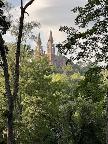
Holy Hill Trailhead
5856-5898 Donegal RoadEnjoy this 6.8-mile point-to-point trail near Hartford, Wisconsin. Generally considered an easy route, it takes an average of 2 h 35 min to complete. This is a popular trail for backpacking, camping, and hiking, but you can still enjoy some solitude during quieter times of day. The best times to visit this trail are April through October. Dogs are welcome and may be off-leash in some areas.
Devil's Lake is Wisconsin's most popular state park and hosts the 11 most popular miles of the Ice Age National Scenic Trail. There is a COMPLIMENTARY Wisconsin State Park Pass available to our guests.* You will need a pass for state park access and parking. Picnic coolers and beach chairs are also available for our guests use. Plan to arrive EARLY! In the summer and fall the number of hikers exploring sections of the IAT at Devil's Lake can number in the thousands each day while several hundred traverse the trail each day in spring and winter. Most hikers here do not realize they are on the IAT. The route follows several trails through the very popular Devil's Lake State Park and features three significant ascents and one probably-not-runnable descent down the East Bluff. There is fantastic scenery throughout.
120 personas locales recomiendan
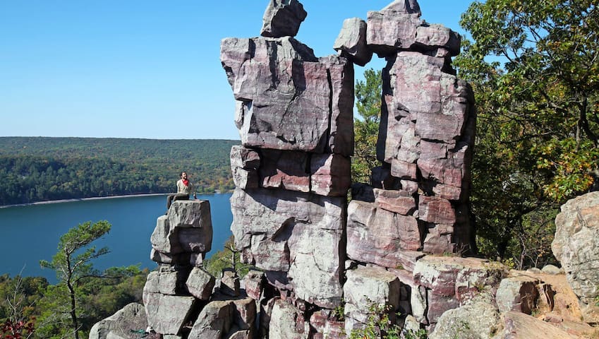
Parque Estatal del Lago del Diablo
S5975 Park RdDevil's Lake is Wisconsin's most popular state park and hosts the 11 most popular miles of the Ice Age National Scenic Trail. There is a COMPLIMENTARY Wisconsin State Park Pass available to our guests.* You will need a pass for state park access and parking. Picnic coolers and beach chairs are also available for our guests use. Plan to arrive EARLY! In the summer and fall the number of hikers exploring sections of the IAT at Devil's Lake can number in the thousands each day while several hundred traverse the trail each day in spring and winter. Most hikers here do not realize they are on the IAT. The route follows several trails through the very popular Devil's Lake State Park and features three significant ascents and one probably-not-runnable descent down the East Bluff. There is fantastic scenery throughout.